
The APSU GIS Center is currently overseeing the Wetlands Project. The center is working with the APSU College of STEM and the Ft. Campbell military base.
APSU Biology students are mapping and validating the wetlands inside a 105,000-acre training area for Ft. Campbell.
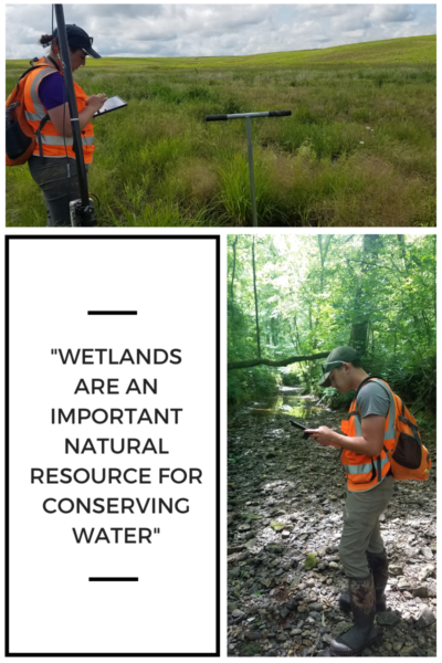
Pictured: APSU students gathering data
Wetlands are an important resource
While wetlands were once thought of as unusable land, we now know that they have many benefits. According to the EPA, wetlands provide “fish and wildlife habitats, natural water quality improvement, flood storage,shoreline erosion protection, opportunities for recreation and aesthetic appreciation, and natural products for our use at little or no cost.”
One student worker explained that the “wetlands are an important natural resource for conserving water. The army base wants to know where the wetlands are in its training area, so they don’t disturb the area.”
The U.S. military recognized their importance, and “have a no net loss policy” for wetlands within military installations. It is estimated that “more than 1.4 million acres of wetlands are located inside U.S. Army installations.”
A New Partnership
Previously, military policy restricted who the army could hire to map wetlands. After these restrictions were loosened, local organizations became an option.
The army’s decision to partner with APSU facilities is more cost-effective. “Fort Campbell expects to save about $187,000 over a three-year period,” compared to the cost of using independent contractors.
APSU also benefits from the partnership. STEM students can gain experience that will help them in their future careers.
The Wetlands Project could continue for up to three years
APSU students began work on the project in January. The students have now moved into the field collection phase. The initial project is expected to be completed in September. However, if the army chooses to continue the partnership the project could be extended for an additional 3 years.
The students use ARC Collector and Survey 123 to map the area. The students take soil samples and measure the level of iron within the soil. They also make notes on plant life and depleted hydric soils.
Some of their progress can be viewed on their iNaturalist page.
To learn more about the Wetlands Project or our other projects, visit our website or contact us at: wilsonm@apsu.edu or 1.931.221.7500
Leave A Comment
You must be logged in to post a comment.